Rick Horton from Greenfield Indiana decided a 40 ft. rattlesnake would look good in his front yard. Here's Rick...

Tuesday, December 28, 2010
Monday, December 27, 2010
Brooklyn, NY Blizzard of December 2010
The following video was taken in Brooklyn, New York. Snow stats from Connecticut, New Jersey, and New York from the New York National Weather Service appear below the video.THE FOLLOWING ARE UNOFFICIAL OBSERVATIONS TAKEN DURING THE STORM THAT HAS BEEN AFFECTING OUR REGION. APPRECIATION IS EXTENDED TO HIGHWAY DEPARTMENTS...COOPERATIVE OBSERVERS...SKYWARN SPOTTERS AND MEDIA FOR THESE REPORTS. THIS SUMMARY IS ALSO AVAILABLE ON OUR HOME PAGE AT WEATHER.GOV/NYC
********************STORM TOTAL SNOWFALL********************
LOCATION STORM TOTAL TIME/DATE COMMENTS
SNOWFALL OF
/INCHES/ MEASUREMENT
CONNECTICUT
...FAIRFIELD COUNTY...
WILTON 18.0 830 AM 12/27 PUBLIC
GREENWICH 17.0 700 AM 12/27 PUBLIC
NORWALK 16.0 910 AM 12/27 PUBLIC
DANBURY 14.1 800 AM 12/27 CO-OP OBSERVER
BRIDGEPORT 12.0 900 AM 12/27 CO-OP OBSERVER
NEW CANAAN 11.0 830 PM 12/26 PUBLIC
COS COB 10.0 1100 PM 12/26 PUBLIC
STAMFORD 10.0 1000 PM 12/26 TRAINED SPOTTER
...NEW HAVEN COUNTY...
SOUTHBURY 11.0 950 PM 12/26 PUBLIC
...NEW LONDON COUNTY...
GALES FERRY 7.5 913 AM 12/27 TRAINED SPOTTER
3 WNW OAKDALE 7.5 700 AM 12/27 COCORAHS
LISBON 7.0 1049 PM 12/26 TRAINED SPOTTER
NORWICH 6.0 800 AM 12/27 CO-OP OBSERVER
LEDYARD CENTER 5.0 730 AM 12/27 TRAINED SPOTTER
NEW JERSEY
...BERGEN COUNTY...
LYNDHURST 29.0 230 AM 12/27 TRAINED SPOTTER
LODI 27.1 700 AM 12/27 PUBLIC
RUTHERFORD 23.0 800 AM 12/27 NJ DEPT OF HIGHWAYS
OAKLAND 22.0 730 AM 12/27 PUBLIC
GARFIELD 21.8 331 AM 12/27 TRAINED SPOTTER
1 W TENAFLY 20.0 700 AM 12/27 COCORAHS
MAHWAH 17.5 1000 PM 12/26 TRAINED SPOTTER
RIDGEWOOD 17.5 622 AM 12/27 TRAINED SPOTTER
PARAMUS 17.0 800 AM 12/27 NJ DEPT OF HIGHWAYS
NORTH ARLINGTON 16.3 1000 PM 12/26 TRAINED SPOTTER
SADDLE BROOK 15.5 1000 PM 12/26 TRAINED SPOTTER
RAMSEY 15.0 1000 PM 12/26 TRAINED SPOTTER
WASHINGTON TOWNSHIP 14.5 1010 PM 12/26 PUBLIC
TENAFLY 11.6 1100 PM 12/26 TRAINED SPOTTER
CRESSKILL 11.5 1000 PM 12/26 TRAINED SPOTTER
HASBROUCK HEIGHTS 11.4 1000 PM 12/26 TRAINED SPOTTER
TEANECK 10.8 1000 PM 12/26 TRAINED SPOTTER
RIVER EDGE 10.5 1000 PM 12/26 TRAINED SPOTTER
ORADELL 10.2 1000 PM 12/26 TRAINED SPOTTER
...ESSEX COUNTY...
NEWARK AIRPORT 24.2 700 AM 12/27 ASOS
VERONA 23.0 500 AM 12/27 PUBLIC
MILLBURN 22.5 800 AM 12/27 PUBLIC
CEDAR GROVE 21.1 700 AM 12/27 PUBLIC
BELLEVILLE 19.4 1130 PM 12/26 TRAINED SPOTTER
WEST ORANGE 17.0 1200 AM 12/27 PUBLIC
...HUDSON COUNTY...
SECAUCUS 25.0 800 AM 12/27 NJ DEPT OF HIGHWAYS
HARRISON 25.0 800 AM 12/27 CO-OP OBSERVER
JERSEY CITY 23.0 800 AM 12/27 NJ DEPT OF HIGHWAYS
HOBOKEN 19.9 800 AM 12/27 SKYWARN SPOTTER
...PASSAIC COUNTY...
CLIFTON 25.0 800 AM 12/27 NJ DEPT OF HIGHWAYS
HASKELL 24.5 200 AM 12/27 TRAINED SPOTTER
WAYNE 22.0 915 AM 12/27 TRAINED SPOTTER
RINGWOOD 22.0 810 AM 12/27 PUBLIC
WEST MILFORD 22.0 415 AM 12/27 TRAINED SPOTTER
...UNION COUNTY...
ELIZABETH 31.8 700 AM 12/27 TRAINED SPOTTER
ROSELLE 28.7 710 AM 12/27 TRAINED SPOTTER
UNION 27.0 745 AM 12/27 TRAINED SPOTTER
CLARK 27.0 745 AM 12/27 TRAINED SPOTTER
FANWOOD 26.0 100 AM 12/27 PUBLIC
NEW YORK
...BRONX COUNTY...
SOUNDVIEW PARK HOMES 22.5 800 AM 12/27 TRAINED SPOTTER
BEDFORD PARK 22.0 600 AM 12/27 PUBLIC
PARKCHESTER 15.7 840 AM 12/27 TRAINED SPOTTER
...KINGS (BROOKLYN) COUNTY...
SHEEPSHEAD BAY 24.0 700 AM 12/27 TRAINED SPOTTER
BROOKLYN 17.5 130 AM 12/27 PUBLIC
...NASSAU COUNTY...
OLD BETHPAGE 20.5 907 AM 12/27 TRAINED SPOTTER
CARLE PLACE 18.1 800 AM 12/27 TRAINED SPOTTER
LONG BEACH 16.0 245 AM 12/27 TRAINED SPOTTER
BALDWIN HARBOR 16.0 800 AM 12/27 TRAINED SPOTTER
SEAFORD 15.5 800 AM 12/27 TRAINED SPOTTER
NEW HYDE PARK 14.2 1155 PM 12/26 TRAINED SPOTTER
FARMINGDALE 14.0 1202 AM 12/27 PUBLIC
OCEANSIDE 13.0 900 PM 12/26 TRAINED SPOTTER
WEST HEMPSTEAD 12.5 800 AM 12/27 TRAINED SPOTTER
ROCKVILLE CENTRE 11.0 1100 PM 12/26 TRAINED SPOTTER
GARDEN CITY 11.0 830 PM 12/26 PUBLIC
BELLMORE 10.0 800 AM 12/27 TRAINED SPOTTER
...NEW YORK COUNTY...
CENTRAL PARK 20.0 700 AM 12/27 ASOS
MANHATTAN 10.0 1020 PM 12/26 SPOTTER-WEST SIDE
...ORANGE COUNTY...
TUXEDO PARK 26.0 255 AM 12/27 PUBLIC
HARRIMAN 26.0 630 AM 12/27 TRAINED SPOTTER
MONROE 24.0 900 AM 12/27 PUBLIC
NEW WINDSOR 17.5 745 AM 12/27 PUBLIC
NEWBURGH 16.5 900 AM 12/27 TRAINED SPOTTER
MONTGOMERY 15.0 100 AM 12/27 PUBLIC
MIDDLETOWN 11.0 100 AM 12/27 PUBLIC
...PUTNAM COUNTY...
4 ESE BEACON 15.0 700 AM 12/27 COCORAHS
8 NE COLD SPRINGS 13.8 700 AM 12/27 COCORAHS
COLD SPRING 13.0 1040 PM 12/26 PUBLIC
PUTNAM VALLEY 13.0 1010 PM 12/26 TRAINED SPOTTER
LAKE CARMEL 11.5 1123 PM 12/26 TRAINED SPOTTER
...QUEENS COUNTY...
ASTORIA 16.1 801 AM 12/27 PUBLIC
NYC/JFK AIRPORT 15.5 700 AM 12/27 ASOS
FRESH MEADOWS 14.2 1225 AM 12/27 PUBLIC
WOODSIDE 14.0 645 AM 12/27 TRAINED SPOTTER
HOWARD BEACH 14.0 1200 AM 12/27 TRAINED SPOTTER
NYC/LA GUARDIA 14.0 700 AM 12/27 ASOS
...RICHMOND COUNTY...
GREAT KILLS 29.0 900 AM 12/27 PUBLIC
ELTINGVILLE 22.0 800 AM 12/27 PUBLIC
STATEN ISLAND 17.8 800 AM 12/27 TRAINED SPOTTER
...ROCKLAND COUNTY...
TALLMAN 10.0 1025 PM 12/26 PUBLIC
VALLEY COTTAGE 7.0 730 PM 12/26 TRAINED SPOTTER
...SUFFOLK COUNTY...
NORTH BABYLON 18.5 845 AM 12/27 PUBLIC
UPTON 17.6 700 AM 12/27 NWS OFFICE
CENTEREACH 17.0 930 AM 12/27 TRAINED SPOTTER
CENTERPORT 15.0 650 AM 12/27 COOP-OBSERVER
EAST SETAUKET 15.0 715 AM 12/27 PUBLIC
1 WNW EAST MORICHES 14.1 745 AM 12/27 COCORAHS
SHOREHAM 14.0 900 AM 12/27 TRAINED SPOTTER
EAST NORTHPORT 13.9 700 AM 12/27 TRAINED SPOTTER
ISLIP AIRPORT 13.7 700 AM 12/27 ASOS
MOUNT SINAI 12.1 700 AM 12/27 NWS EMPLOYEE
HOLBROOK 11.5 430 AM 12/27 PUBLIC
PORT JEFFERSON 11.0 800 AM 12/27 PUBLIC
ORIENT 10.0 1230 AM 12/27 PUBLIC
FLANDERS 10.0 620 AM 12/27 TRAINED SPOTTER
...WESTCHESTER COUNTY...
YONKERS 19.5 800 AM 12/27 TRAINED SPOTTER
MOUNT VERNON 17.0 1115 PM 12/26 BROADCAST MEDIA
BRONXVILLE 17.0 1140 PM 12/26 PUBLIC
EASTCHESTER 14.5 1037 PM 12/26 PUBLIC
PORT CHESTER 14.0 1015 PM 12/26 PUBLIC
BRIARCLIFF MANOR 13.1 810 AM 12/27 PUBLIC
2 NW SOUTH SALEM 13.0 800 AM 12/27 COCORAHS
DOBBS FERRY 12.0 1100 PM 12/26 TRAINED SPOTTER
SCARSDALE 11.5 1115 PM 12/26 TRAINED SPOTTER
WHITE PLAINS 11.0 1030 PM 12/26 WHITE PLAINS HS
HASTINGS-ON-HUDSON 11.0 1100 PM 12/26 PUBLIC
LARCHMONT 11.0 1000 PM 12/26 TRAINED SPOTTER
East Coast Blizzard
This timelapse was taken in Belmar, New Jersey during the blizzard on December 26th, 2010.
December 2010 Blizzard Timelapse from Michael Black on Vimeo.
Sunday, December 19, 2010
Marching Band on the Move...
Did you see the University of Hawaii's marching band when Hawaii played USC back in september? Not many people saw it live as evidenced by the lack of fans in the seats. I'm guessing this is going to be a trend with university marching bands.
Friday, December 17, 2010
I Want to Drive a Train Plow....
This video is not new but it sure is fun to watch-especially full screen. This video was taken about two years ago as the train plow ran from Bethune to Stratton, Colorado. Don't Forget....full screen!
Lighthouse Goes Icehouse
It looks like Mr. Freeze has been at work in the old Batman TV series when you see what has happened to a lighthouse on Lake Erie. Wind, freezing cold, waves, and lake spray have transformed the lighthouse into an icehouse. Holy fresh water ice castle Batman!
Thursday, December 16, 2010
A Break From the Snow
After working hand-in-hand with Mother Nature I like to decompress a bit. I found myself laughing at something from BBC One that I fumbled into on Youtube. Sit back, relax and enjoy the foolishness.
Sunday, December 12, 2010
MetroDoom...
The Minneapolis area saw 17 inches of snow with the same storm that brought Cincinnati 2"-4" of snow. The inflatable, teflon coated fiberglass roof on the metrodome could not take the weight of the snow. The game between the Vikings and the Giants has been moved to Detroit and will be played Monday night.
Thursday, December 9, 2010
Syracuse gets Hammered...
Thursday, December 9th, 2010
Helloooo Syracuse! Syracuse, New York has just seen a 4-day snowfall total of 42.3" That's just shy of the city's all-time 4-day snowfall record of 44.6" set in 1966 beginning on January 29th.
When a cold air mass moves over a warm body of water, like one of the Great Lakes, the bottom layer of the cold air mass is warmed and water is evaporated into that layer. The warmer and moist layer is lighter than the arctic airmass and rises through the cold air. As it does so, the parcel of air cools and moisture condenses into clouds. If enough moisture is available snow will begin to fall. The clouds and snow get pushed ashore by the winds. Friction of the land slows the winds and allows more snow to fall, and if winds move uphill onshore snowfall rates can be greatly enhanced. Here are a few diagrams from the University of Illinois.

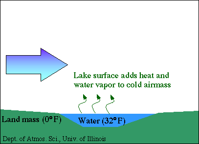


Occasionally, winds will blow from NNW to SSE over Lake Michigan as an Arctic air mass plunges into the United States. If the winds are strong enough and the temperature contrast between Lake Michigan and the air mass is wide enough we can see lake-enhanced snow in Cincinnati
Wednesday, December 8, 2010
Quite the Formula
Wednesday, December 8, 2010
We toss around the term "wind chill" without hesitation during cold spells like the one we are seeing right now. If you sit and think about it for just a second wind chill is a pretty complicated indicator. How cold does the temperature combined with the wind feel on your face? At what temperature, wind speed, and exposure time will frostbite occur? The first index used by the United States and Canada was based on research done by Antarctica explorers Siple and Passel in 1945. In 2001 the Office of the Federal Coordinator for Meteorological Services and Supporting Research decided that the index set forth in 1945 needed revising because it underestimated the time to freezing and overestimated the chilling effect of the wind. A group called the Joint Action Group for Temperature Indices or JAG/TI was organized by the U.S. and Canadian governments to upgrade and standardize the Wind Chill Index. Human trials were conducted in Toronto, Canada. Twelve volunteers were placed in a chilled wind tunnel with thermal transducers on their faces to measure heat flow from the cheeks, forehead, nose, and chin while walking 3 mph on a treadmill. Each was exposed to varying wind speeds and temperatures. A new wind chill formula was created using the information obtained along with advances in science, technology, and computer modeling to provide a more accurate formula for computing the Wind Chill Index. And, for the first time the new Wind Chill Chart includes a frostbite indicator showing where temperature, wind speed , and exposure time will produce frostbite on humans.
 This new Wind Chill Index now being used by the U. S. and Canada does the following according the the National Weather Service:
-Calculates wind speed at an average height of five feet, typical height of an adult human face, based on readings from the national standard height of 33 feet, typical height of an anemometer
-Is based on a human face model
-Incorporates heat transfer theory, heat loss from the body to its surroundings, during cold and breezy/windy days
-Lowers the calm wind threshold to 3 mph
-Uses a consistent standard for skin tissue resistance
-Assumes no impact from the sun (i.e., clear night sky).
The following is the current Wind Chill formula:
where and are measured in °F, and in mph
The graph below indicates the difference between the old and new Wind Chill indicies.

We toss around the term "wind chill" without hesitation during cold spells like the one we are seeing right now. If you sit and think about it for just a second wind chill is a pretty complicated indicator. How cold does the temperature combined with the wind feel on your face? At what temperature, wind speed, and exposure time will frostbite occur? The first index used by the United States and Canada was based on research done by Antarctica explorers Siple and Passel in 1945. In 2001 the Office of the Federal Coordinator for Meteorological Services and Supporting Research decided that the index set forth in 1945 needed revising because it underestimated the time to freezing and overestimated the chilling effect of the wind. A group called the Joint Action Group for Temperature Indices or JAG/TI was organized by the U.S. and Canadian governments to upgrade and standardize the Wind Chill Index. Human trials were conducted in Toronto, Canada. Twelve volunteers were placed in a chilled wind tunnel with thermal transducers on their faces to measure heat flow from the cheeks, forehead, nose, and chin while walking 3 mph on a treadmill. Each was exposed to varying wind speeds and temperatures. A new wind chill formula was created using the information obtained along with advances in science, technology, and computer modeling to provide a more accurate formula for computing the Wind Chill Index. And, for the first time the new Wind Chill Chart includes a frostbite indicator showing where temperature, wind speed , and exposure time will produce frostbite on humans.

-Calculates wind speed at an average height of five feet, typical height of an adult human face, based on readings from the national standard height of 33 feet, typical height of an anemometer
-Is based on a human face model
-Incorporates heat transfer theory, heat loss from the body to its surroundings, during cold and breezy/windy days
-Lowers the calm wind threshold to 3 mph
-Uses a consistent standard for skin tissue resistance
-Assumes no impact from the sun (i.e., clear night sky).
The following is the current Wind Chill formula:
where and are measured in °F, and in mph
The graph below indicates the difference between the old and new Wind Chill indicies.

Thanks to National Weather Service
Monday, December 6, 2010
A Great Timeout....
Monday, December 6th, 2010
Last Friday myself and my much better half ventured from Cincinnati to Penn State University for an NCAA Championship first round volleyball match between the three-time defending national champions Nittany Lions and the Purple Eagles from Niagara University of New York. Round trip the drive is about 15 hours from Cincinnati to watch a match that lasts about an hour and a half. My daughter is my vested interest, she is a proud junior Purple Eagle volleyball player. There are many proud Purple Eagles, even more now.
Last Friday myself and my much better half ventured from Cincinnati to Penn State University for an NCAA Championship first round volleyball match between the three-time defending national champions Nittany Lions and the Purple Eagles from Niagara University of New York. Round trip the drive is about 15 hours from Cincinnati to watch a match that lasts about an hour and a half. My daughter is my vested interest, she is a proud junior Purple Eagle volleyball player. There are many proud Purple Eagles, even more now.
Here is a little background. Two years ago the Niagara volleyball team was the youngest NCAA Division 1 team of any NCAA sport. Their average age as a team was just over 18 years. The team struggled going 6-23 on the season in a small D1 conference. Despite the struggle, every player on the roster returned, the team had developed a family atmosphere under Head Coach Susan Clements and Assistant Coach Kara Hellman. The Eagles went 23-8 last year. It was the biggest turn-around by any NCAA volleyball team. Still very young, the Eagles won the MAAC Championship and headed to the NCAA tournament for the first time in Niagara's history. They were ousted quickly in the first round by a very strong Michigan team. The match was brief and uneventful. The Eagles were determined to return to the NCAA tournament.
This year the Purple Eagles won the MAAC conference with a 17-1 record, won the MAAC championship, and advanced to the NCAA tournament. Their draw was three time defending national champion Penn State! Penn State's front line goes 6'5", 6'4", and 6'3". That's height in feet and inches. The Eagles measure in at 6'1", 6'0, and about 5'10". While Niagara has an enrollment of about 3700, Penn State sees about 44,000 kids enroll. Most thought the match was destined to be a short affair.
 One of goals of the Purple Eagles was simple-keep a game in the match close enough to make Penn State call a timeout. That means you have to play with Penn State, point for point, eventually making them nervous enough to call a timeout. It happened in the second game of the 3 game sweep. The score was close early on. Purple Eagle fans snapped pictures of the scoreboard with Niagara leading 4-2 and 8-6. It looked, however, as though Penn State was going to pull away when the score went to 18-14 in favor of the Nittany Lions. The Purple Eagles scored 4 straight and then it happened. Legendary Penn State coach Russ Rose, clipboard in hand, motioned to the ref for a timeout. From 6-23 two years earlier in a small D1 conference to a Penn State timeout in the NCAA tournament. Purple Eagle fans danced, laughed, slapped hands and enjoyed a timeout like they had never before.
The Purple Eagle women athletes had accomplished one more goal. In terms of volleyball and programs and development and maturity and effort this was a big one, a very big one. Somehow, someway, this group mustered enough grit and determination, while knowing the mismatch that exisited, to concentrate on and succeed at the task at hand. That's hard to do. I have seen many individual athletes develop over time but watching an entire team develop is an absolute thrill.
Penn State went on to win the game and eventually the match. I saw the Penn State players go their seperate ways as they left the arena. The Purple Eagles went to dinner, together.

Monday, September 20, 2010
Uranus is Big but Jupiter is Huge Tonight
Sorry, that never gets old. Jupiter is close tonight. The next time it will be this close is 2022. It is a mere 368 million miles away.

As I blog, (8:45pm), Jupiter is rising in the east and will be directly overhead at 12:43am ET. Jupiter is the brightest thing in the sky aside from our moon.

Uranus will also be visible and will appear just above Jupiter as a greenish star.
Friday, September 17, 2010
Is blogging for me?
I am not so sure that blogging is for me... The word "blogging" has never appealed to me. The word seems sluggish, uninspiring, and caloric. That's right..."blog" seems like it should be high in calories. If I "blog" too much will I get fat? If I blog too much will my thoughts become uninspired. Will I start moving slower and become lethargic.
When I think of a "blogger" I never think of a fast runner. I never think of an inspirational speaker. I think of slow and boring catapillars. So I will consider this "blogging" thing carefully. Until I reach my decision, enjoy your weekend and ponder the Cincinnati 7-Day Forecast.

When I think of a "blogger" I never think of a fast runner. I never think of an inspirational speaker. I think of slow and boring catapillars. So I will consider this "blogging" thing carefully. Until I reach my decision, enjoy your weekend and ponder the Cincinnati 7-Day Forecast.

Subscribe to:
Posts (Atom)