
Thursday, December 9th, 2010
Helloooo Syracuse! Syracuse, New York has just seen a 4-day snowfall total of 42.3" That's just shy of the city's all-time 4-day snowfall record of 44.6" set in 1966 beginning on January 29th.
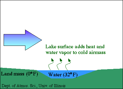
When a cold air mass moves over a warm body of water, like one of the Great Lakes, the bottom layer of the cold air mass is warmed and water is evaporated into that layer. The warmer and moist layer is lighter than the arctic airmass and rises through the cold air. As it does so, the parcel of air cools and moisture condenses into clouds. If enough moisture is available snow will begin to fall. The clouds and snow get pushed ashore by the winds. Friction of the land slows the winds and allows more snow to fall, and if winds move uphill onshore snowfall rates can be greatly enhanced. Here are a few diagrams from the University of Illinois.


Occasionally, winds will blow from NNW to SSE over Lake Michigan as an Arctic air mass plunges into the United States. If the winds are strong enough and the temperature contrast between Lake Michigan and the air mass is wide enough we can see lake-enhanced snow in Cincinnati
No comments:
Post a Comment